On Soundings Navigation™
Passage planning in shallow water: tides, squat and under-keel clearance.
A ship is on soundings where the lead finds bottom. That is where this program works: on a river bar, in a dredged channel, over a shallow approach, wherever the question is how much water will be under the keel, when, and at what speed.
Give it the ship, the route and the tide tables. It works out the height of tide along the whole route, the squat at every speed, and the speed to order at each waypoint, so that the shallow places are passed on the right tide with the under-keel clearance you require.
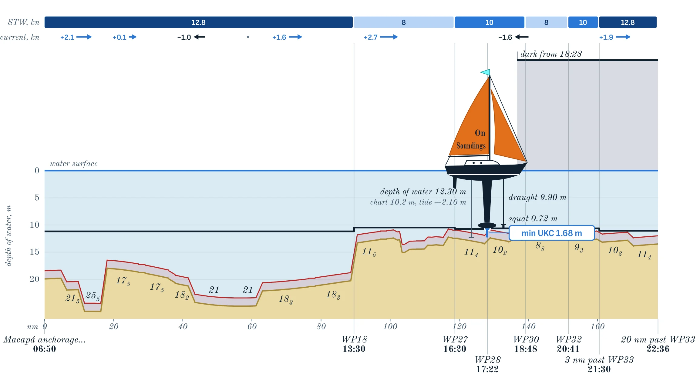
What it works out
The plan follows every entry; there is no button to press.
- The tide along the whole route
- High and low waters, or heights at every hour, for any number of tidal stations: typed, pasted from the published table, or read from the PDF of the table (two makes of table so far). Between the stations the time and the height of each tide are carried along the route by distance, so every leg has its own tide for the time the ship is on it.
- Squat
- By Barrass, by ICORELS, or from the ship’s own squat table; in open or confined water, with the width of the channel where it matters. Draught is corrected for the density of the water on each leg.
- Departure and speed orders
- You say what matters: the greatest clearance, the earliest arrival with the clearance required, as little darkness as possible, or a speed of your own. The program finds the time to leave and the speed to order at each waypoint. Single legs can be kept to daylight, and waiting allowed where the ship can wait.
- Current
- Rates entered leg by leg or, where none are known, a tidal stream estimated from the tide tables themselves and marked as an estimate. Speed over the ground stands beside speed through the water on every leg.
- The route from the ECDIS
- Waypoints typed, pasted, or taken from a route file (RTZ, RTZP, GPX) together with the XTD of each leg. A corrected route keeps the depths already entered on the legs that did not move.
- The least depth of each leg, against the chart
- A raster chart opened as a file (GeoTIFF) is shown with the route on it. Where the program can read the chart’s figures, it proposes the least sounding within the XTD of each leg; the figure is always yours to take or to change. Where it cannot, the chart is a picture with the route on it.
- Under way
- Type the actual time of passing a waypoint and the rest of the plan is worked out again from it. With a position from the GPS of a tablet or from the ship’s AIS, the program shows the leg she is on, how far she is off the track against the XTD, the minutes ahead of or behind the plan, and the current as measured.
- On board
- One page that works in the browser of a computer without internet, in English and in Russian, with colours for day and for night. The plan can be locked against changes by accident, saved to a file and passed to another ship.
The plan, on paper and under way
The pictures are of the example passage that comes with the program; the ship in it is called MV Example.
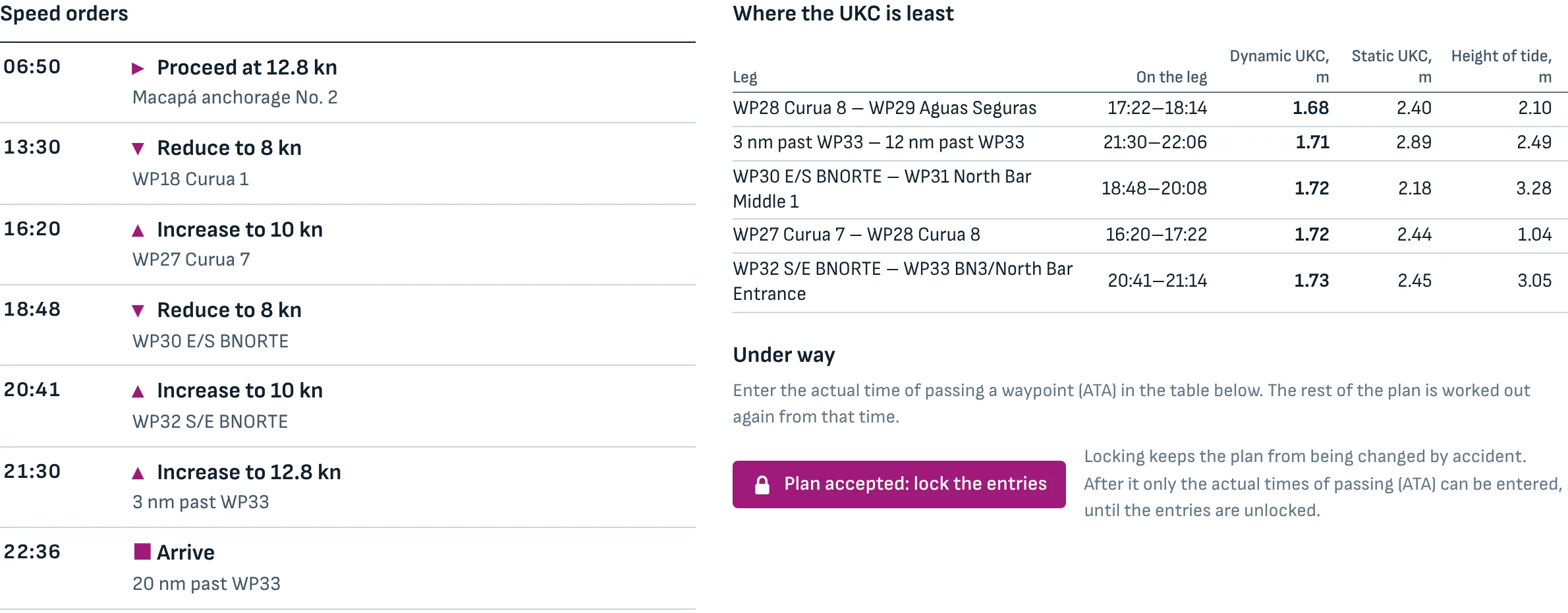
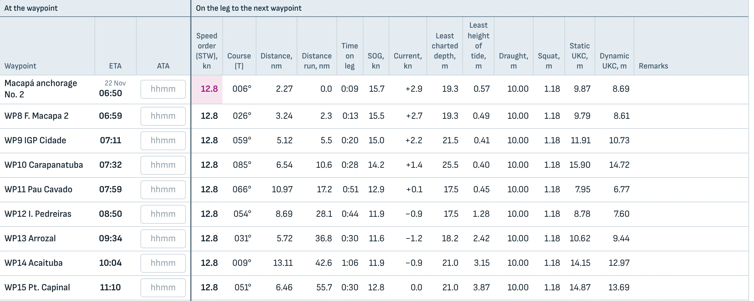
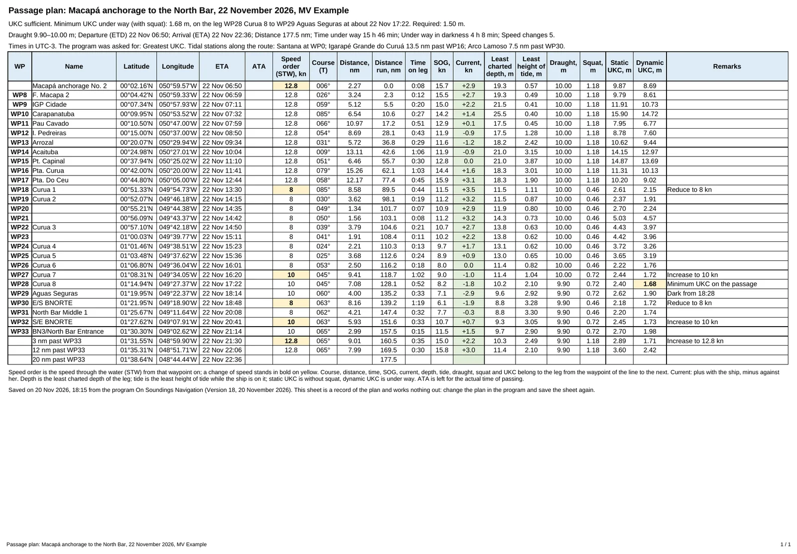
A sheet for the bridge file
The verdict, the facts of the passage, the tidal stations used and every leg of the plan stand on one page, with a column left empty for the actual times of passing.
The sheet holds figures, not formulas: it is a record of the plan as it was worked out, to be printed, signed and kept.

Where it stands
November 2026. The program is still being built and tried by its author. It is not released and not on sale, and it is not offered for download here.
Some parts are so far proved only on the bench and not yet at sea: the position of the ship from the GPS or the AIS, and the program as an app on a tablet.
It does not take the place of the official charts and publications, the ECDIS, the echo sounder, the ship’s own squat data, the pilot, or the judgement of the Master and the officer of the watch.
Terms of use
- Check every figure
- What comes out depends on what is put in and on methods that are approximations. A predicted tide is not the tide that comes; a charted depth is not the depth that is there today; an estimated current is an estimate. Check the results against official sources before relying on them, and keep watching the echo sounder.
- Charts and tide tables are yours
- The program brings no charts and no tide tables with it; its example carries a few days of predictions as an illustration only. The files you open stay on your device. It is for you to see that you may use them and that they are up to date. A chart opened as a picture is not corrected by Notices to Mariners and is not for navigation.
- Position of the ship
- Where the program shows the ship, the position is the one your device or your AIS gives, and the mark on the chart is not to scale. It is an aid to watching the plan, never the means of fixing the ship’s position.
- No warranty
- The program is offered as it is, without warranty of any kind. As far as the law allows, the author is not liable for loss or damage that comes from its use or from relying on its results. The safe navigation of the ship stays with those in charge of her.
- Your data
- The plan, the charts and the tide tables are kept in the store of the browser on your device and nowhere else. The program sends nothing to its author or to anyone.
- Rights
- The program, its texts and its pictures, and the texts and pictures of this page, may not be copied, changed, sold or passed on without the written permission of the author. The type of this page is Old Standard TT, used under the SIL Open Font License 1.1.